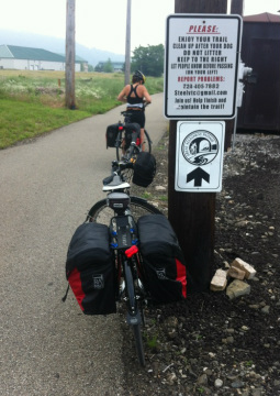
 At the GAP outside Pittsburgh.
History of the GAP
Completed in 2013, the Great Allegheny Passage (GAP) rail-trail offers 150 miles of hiking and biking between Cumberland, MD, and Pittsburgh, PA. In Cumberland, the GAP joins the C&O Canal Towpath, creating a continuous 335 mile long trail experience to Washington, DC.
Much of the Great Allegheny Passage is built on the abandoned grades of the Western Maryland Railway (WMR) and the Pittsburgh and Lake Erie Railroad (P&LE). They join at Connellsville and make up the majority of the trail between Cumberland and Pittsburgh.
The B&O paralleled the WMR and P&LE all the way from Cumberland to Pittsburgh; at times the two railroads were little more than a stone's throw apart. After World War I, the B&O gained control of the Western Maryland, but due to federal regulations, still had to operate the WMR as a separate - and competitive - line.
Western Maryland's management ran a fine railroad, but by the late 1960s forecasts for the line were ominous. Costs were rising and income was declining. WMR's managers petitioned the owners to throw in the towel and merger. Merger proceedings were begun.
In 1975, the Western Maryland, by now part of the Chessie System, successor to the B&O, was formally abandoned as a through route, although short sections were retained to serve local coal mines well into the 1980s. The Chessie System is now CSX.
After the P&LE Yough Branch lost its connection with the WMR in 1975 and the last big coal mine on the line closed in 1982, there was little traffic left and in 1991, it too was abandoned.
 On the crushed gravel surface of the GAP.
Origin of the trail
The Great Allegheny Passage can trace its beginning to June 9, 1978, when the Western Pennsylvania Conservancy purchased the first property that would become the GAP from the Western Maryland Railway Company.
In 1978, the Western Pennsylvania Conservancy, on behalf of the Commonwealth of Pennsylvania, purchased 27 miles of the railroad in the Yough Gorge from Connellsville to Confluence. Nine miles of trail from Ohiopyle to Ramcat, near Confluence, were opened in 1986. This was the best possible advertisement for the rails-to-trails movement; people flocked to it by the thousands, then hundreds of thousands.
Rail trail groups formed all along the corridor and it became apparent that a continuous trail was possible from Pittsburgh to Cumberland to Washington, DC. A Trail Summit was held in September, 1995. The consensus of the Summit was that the contiguous trail organizations should unite and the Allegheny Trail Alliance was born.
In 2001, the trail was christened the Great Allegheny Passage with its own logo, and later in the year 100 continuous miles were opened from Meyersdale to McKeesport.
Now completed, the Great Allegheny Passage is 150 miles long from Pittsburgh to Cumberland with a 52-mile spur to the Pittsburgh International Airport.
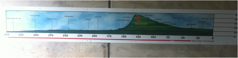
Elevation chart from Pittsburgh (right) to Georgetown (left) found in the East Continental Divide Tunnel.
 Mules on the towpath towed boats on the water.
History of the C&O Canal
Preserving America's early transportation history, the Chesapeake & Ohio (C&O) Canal began as a dream of passage to Western wealth. Operating for nearly 100 years, the canal was a lifeline for communities along the Potomac River as coal, lumber and agricultural products floated down the waterway to market.
The canal is about 184.5 miles (296.9 km) long between Cumberland, MD and Georgetown, in Washington DC. The elevation change of 605 ft (184 m) was accommodated with 74 canal locks. Major streams were crossed with 11 aqueducts; more than 150 culverts were built to allow the canal to cross smaller streams. The canal also passes through the 3,118 ft (950 m) Paw Paw Tunnel.
Construction of the Chesapeake and Ohio Canal began in 1828 and the canal opened new sections as it reached a dam and the feeder lock behind it that could provide water to the section of canal below. Upstream from Dams 4 and 5 the canal was interrupted by rocky ridges rising steeply from the river. To avoid the expense of blasting through them, the canal was discontinued and locks allowed boats to enter the slackwater pools behind the dams. A narrow towpath along the river’s edge was created for the mules. Dam 4’s “Big Slackwater” section was 3½ miles long, while “Little Slackwater,” above Dam 5 was a mere half a mile long. Navigating in the slackwater sections was more hazardous than in the canal, and many fatal accidents took place.
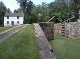 A lockhouse near a lock.
Between Dam 6, ten miles above Hancock, and Cumberland’s Dam 8 at mile 184.5, are fifty mountainous miles where construction came to a virtual halt for several years in the early 1840s. As a result it was not until October 10, 1850, that the canal finally opened from Dam 8 at the Cumberland terminus. By then it was generally accepted that the canal would go no farther despite the original plan to reach the Ohio River.
Once the canal opened to Cumberland, coal rapidly became the primary cargo with shipments reaching between 797,000 and 905,000 tons a year during the canal’s most prosperous years of 1870 to 1875. Not until the third quarter of the 19th century did railroad technology reach a point where it could compete with canals in the transportation of heavy freight (although railroads had rapidly proved superior for the transportation of passengers and lighter cargo, such as agricultural produce).
During the construction years numerous misfortunes slowed the canal’s progress and increased costs, including epidemics of diseases such as Asiatic cholera, labor unrest and shortages, and national economic downturns. But chief among the canal company’s difficulties, continuing throughout its history, was the damage done by periodic floods.
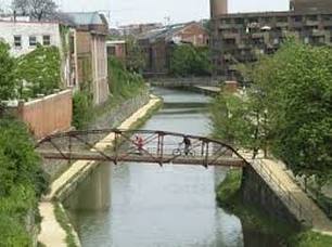 The Canal Bridge at Georgetown.
During the Civil War the canal served to transport military supplies and personnel and was important to the provision of coal and agricultural products for the federal government and the District cities of Washington, Georgetown, and Alexandria. The canal’s direct route to the tidewater port of Georgetown was an advantage not possessed by the B&O whose mainline ran north and east from Point of Rocks to Frederick and Baltimore. Not until 1873 would the B&O open its Metropolitan line directly into the Federal District, although it still lacked access to the industries and wharfs at Georgetown.
On June 1–2, 1889, a flood that eclipsed all previous recorded floods in the Potomac Valley did devastating damage to the canal, as well as other transportation routes, bridges, businesses, and homes near the Potomac and many of its tributaries. Already deeply in debt, the C&O Canal Company had no choice but to declare bankruptcy. On March 3, 1890 the court appointed receivers under the mortgage of 1844 to restore and operate the canal. The canal reopened in September, 1891, and was operated under the receivership until the flood of 1924 when the court gave permission to discontinue operation following damage by yet another flood.
In 1938 the canal was sold to the government by the B&O Railroad whose ownership was based on their holdings of the 1844 bonds that mortgaged the canal property and repair bonds of 1878. In 1971, after a long struggle on the part of a diverse constituency, the C&O Canal became the C&O Canal National Historical Park.
Throughout its 22 years of construction and nearly a century of operation, the canal was home to countless men, women, and children who worked at locks or on boats. In addition it employed a wide variety of craftsmen, laborers, engineers, and administrative or supervisory personnel. In addition to its heavy use by the large coal companies, it was relied on by farmers, businesses, and individuals to transport goods in both directions, ranging from fertilizer from South America to salted and pickled seafood and fish from the tidewater.
Today, the canal way is now maintained as a park, with a linear trail following the old towpath, the C&O Canal National Historical Park. Hikers, bikers, runners and history enthusiasts can still enjoy this fabulous example of 19th century canal engineering.
